GISCafe Weekly Review November 2nd, 2018

GISCafe Voice spoke with Lisa Cali, Senior Product Manager, IndoorViewer about NavVis’s latest software upgrade to their web-based application NavVis IndoorViewer. A provider of indoor spatial intelligence technology, NavVis is now able to automatically convert E57 point cloud files into interactive, realistic 360° walkthroughs, with the latest software upgrade to IndoorViewer.

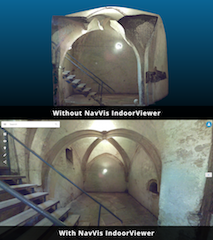
NavVis IndoorViewer Upgrade Automatically Renders 360° Immersive Imagery from E57 Point Clouds. Top photo: E57 point cloud file, captured by a static laser scanner Bottom photo: E57 point cloud file automatically converted into an immersive 360° walkthrough in NavVis IndoorViewer

Penn State
Teledyne Optech
Teledyne:


You are registered as: [[email protected]].

CafeNews is a service for GIS professionals. GISCafe.com respects your online time and Internet privacy. Edit or Change my newsletter's profile details. Unsubscribe me from this newsletter.

Copyright © 2018, Internet Business Systems, Inc. — 25 North 14th Steet, Suite 710 San Jose, CA 95112 — +1 (408) 882-6554 — All rights reserved.